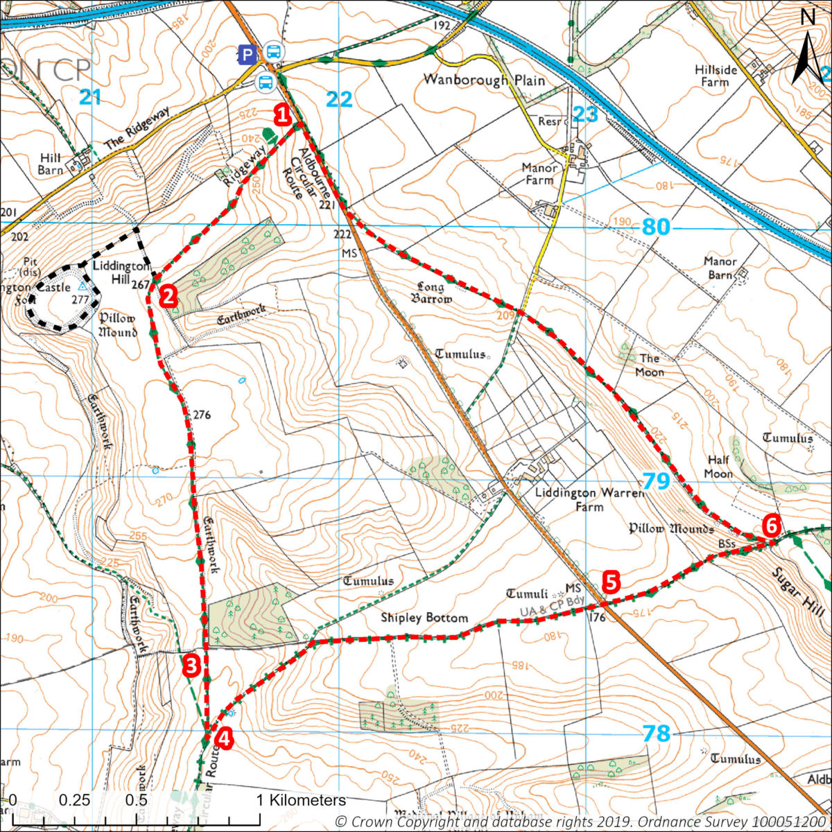
A lovely walk on chalk hills with stunning views of the countryside of the North Wessex Downs. Less than 5 miles from Swindon it includes the option of visiting the site of Liddington Castle Iron Age hillfort.
Useful Info
- 4.5 miles / 7.5 km circular
- Public Transport: Buses between Hungerford and Swindon stop at Foxhill Turn, no Sunday service. See Stagecoach website.
- Parking: on road laybys close to bus stops.
- Start Point for walk:
What3 words: ///simulator.spill.winner
Grid Ref: SU218804
- OS Explorer map 157 Avebury & Devizes.
- Mostly unmade paths and can get muddy. One short steep ascent. Several gates. No stiles. Busy road crossings.
- Nearest pubs: The Village Inn at, Liddington. The Blue Boar and The Crown at Aldbourne
- GPX Links:
Click to download Liddington Hill circular
Click to download Liddington Hill extra
Route Directions
- Beside a metal field gate, follow The Ridgeway bridleway up the stony farm track ahead. At the top of the slope, near Liddington Clump, it curves gently to the right.
- After passing through a gate either continue on The Ridgeway path down the slope or take a short detour to the Liddington Castle hillfort (see Points of Interest below). Hillfort detour (this adds approx. 1 mile/1.6 km to the walk): Follow the field edge path to the right, up the slope. Go through a kissing gate, then left along the fence line. Pass through a metal gate to visit Liddington Castle. Return back through the same gates and re-join main route.
Continue southwards on The Ridgeway path which starts to go gently downhill. - At the end of the field fence go through the gate on your left, turn immediately right through the gap to continue along The Ridgeway. Follow the track for approx. 300m.
- At a junction of tracks marked by fingerposts, turn sharp left, leaving The Ridgeway. Stay on the wide chalk track (marked as Byway/Aldbourne Circular short cut) until you reach the Aldbourne road B4192. (Note: as a byway this track may be used by motor vehicles during the summer)
- Cross the road and follow the chalk track ahead, rising steeply onto Sugar Hill.
- At the top of the slope, go through the field gate and immediately left through a small gate. Continue left on the track next to the fence, known locally as the “Thieves’ Way” (see Points of Interest below). Follow the path through four gates and then adjacent to the road for the final stretch back to the start of the walk.
To return to bus stops or parking, continue along the field path for a further 200m to a wooden gate and fingerpost. Go through the gate and turn right onto the grass verge.
Points of Interest
- Liddington Castle – is the site of an Iron Age hillfort. It was first occupied around 700 BC and is one of the earliest hillforts in Britain. It commanded the head of the River Og valley, one of the main approaches into Wessex from the north. It was a favourite haunt of Richard Jefferies, the 19th century local writer of natural history and rural life. From here he enjoyed a view “over broad plain, beautiful with wheat and enclosed by a perfect amphitheatre of green hills”. There is a memorial at Liddington Castle to him and another writer Alfred Williams. Nearby is the Richard Jefferies Museum, see Home (richardjefferies.org)
- Thieves’ Way – the track between 6) and 7) – is part of an old Saxon route and was probably used as a drove way for stolen cattle. It is also the parish boundary marked by large sarsen stones. Sugar Hill probably gets its name from “Segur” the name of a local 12th century landowner.
- The Ridgeway – is one of 15 designated long-distance National Trails in England and Wales. The original trackways are thought to be the oldest road in the country, in existence since Neolithic times some 5,000 years ago. The modern Ridgeway National Trail was created in 1972; shorter than the ancient trackway it is 87 miles/140 km between Overton Hill, Wiltshire and Ivinghoe Beacon, Buckinghamshire.
-
Chalk downland is a rare and special habitat for wildlife including flowers, butterflies, and birds. In the summer look out for marbled white butterfly, six-spotted burnet moth; birds such as the skylark, corn bunting, linnet, yellowhammer and red kite. In the winter look out for fieldfare and redwing. All year round rabbits, hares and deer can be seen. Blackthorn, hawthorn and elder are common hedgerow trees. Beech trees are often planted in clumps along the ridgelines.


