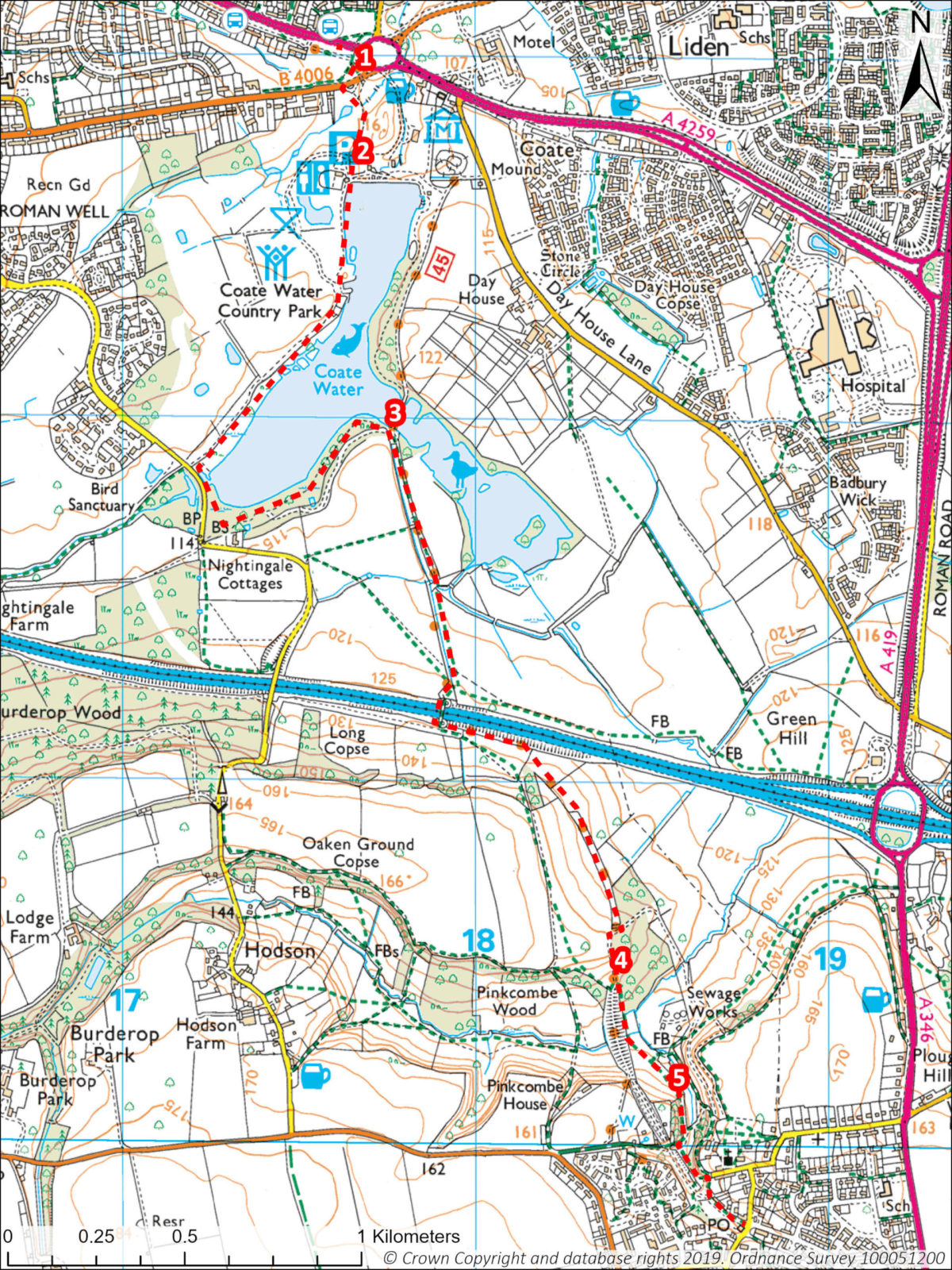
Accessible by bus from Swindon, this walk takes you through Coate Water Country Park, across the boundary into the North Wessex Downs and along part of the old Swindon to Marlborough Railway path to Chiseldon. You can make a longer route by walking back but round the other side of Coate Water.
Useful Info
- 3 miles/4.8km linear
- Start point: Coate Water kiosk/cafe
- Buses: several from Swindon town stop at Coate Water, see Stagecoach website
- What3words: ///wheat.brew.potato (bus stop) /// polo.idealist.whimpered (kiosk)
- Grid ref: SU176826 (kiosk)
- OS Explorer Map: 169 Cirencester & Swindon
- No stiles, some gates. Slight gradients on parts of the walk. Can be muddy in places.
- Refreshments: Kiosk/cafe at Coate Water. Patriot’s Arms Bar & Café in Chiseldon (western end of New Road).
Three Trees Farm Shop & Café in Chiseldon, 10 mins walk at the end of the route – continue on Station Road, cross New Road (where there is a bus stop) and along the old railway line parallel to the allotments. - GPX: Click here to download
Route Directions
- From the Coate water bus stop, walk towards the roundabout then take the path right that goes under the A4259. Cross the cycle path and fork off to the left under another underpass, continue on through the park and you will reach Coate Water.
- From Coate Water car park, walk up to the water’s edge and kiosk. Follow the path keeping the lake on your left. When you reach the end of the lake (golf course on your right) and a road, keep to the left on a path running parallel to the road. Further on, fork left over a small wooden bridge with the lake still on your left.
- On reaching a junction of paths, ignore the footbridge over the lake and continue straight ahead along the path signed Hodson and Chiseldon. The path is part of the Timberland Trail for walkers and cyclists. Continue straight ahead on the track, then cross the M4 Motorway via the concrete helter skelter bridge. Liddington Hill is clearly visible at this point. Follow the tarmac cycle path through an area of oak and ash woodland (noted for its bluebells in late Spring). Continue for some distance.
- When the path merges with the old Swindon to Marlborough Railway path (see Points of Interest below). Turn left and almost immediately, take another left off the railway path, to follow a footpath signed Chiseldon. Follow this short steep path downhill to a kissing gate, then across a field (keeping the stream on your left) to the top left-hand corner and another kissing gate.
- Continue along a path to a junction of paths at Washpool. Continue ahead (not under the railway arch) along a narrow tarmac path, bearing left gently uphill to a flight of steps. Ignore the steps and bear right along the path passing the front of the first properties on Strouds Hill. Continue ahead to reach the junction of Chiseldon High street and Station Road and a bus stop.
An alternative return route to Swindon would be to retrace your steps to point 3, then cross the bridge to walk around the other side of Coate Water back to the car park.
Points of Interest
- The Swindon to Marlborough railway line was constructed in 1881 and was at its busiest during the First World War with trains full of troops, horses, and equipment. The railway closed in 1967 and the cycle path created in 1988. The Path is part of the Sustrans National Cycle Network.
- The Richard Jefferies Museum SN3 6AA Home (richardjefferies.org)
- The Chiseldon Museum SN4 0NW The Museum – CLHG (chiseldonlhg.org.uk)


