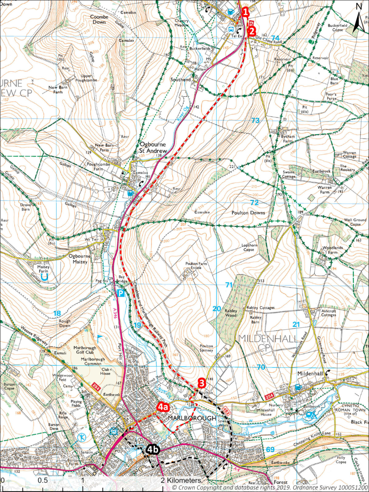
A gentle walk mostly on surfaced paths following the route of an old railway line south of Swindon to the historic town of Marlborough. There is a good bus service linking the start and the finish of the walk.
Useful Info
- 5 miles / 8 km linear
- Start point: Inn with the Well, Ogbourne St George
- What3words: ///head.cats.marker
- Grid Ref: SU202742
- OS Explorer Map: 157 Avebury & Devizes
- On-road parking
-
- Buses between Swindon and Marlborough stop in Ogbourne St George, bus stop Telephone Box, see Stagecoach website for information
- Mostly flat, mostly on good paths
- Refreshments: pub in Ogbourne St George. Pubs, cafes etc in Marlborough
- GPX: Click to download Route A, Click to download Route B
Route Directions
- Start in Ogbourne St George with the Inn with the Well pub on your right. Walk along the road under a bridge (the A346 road between Swindon and Marlborough). Almost immediately turn right into a minor road signed Bytham Farm. After about 250m, turn right onto Chiseldon to Marlborough Railway Path.
- Continue along this path for just under 6.5 kms. Look out for remnants of the old railway — there is a derelict signalman’s hut.
- When the path crosses a minor road (finger post Marlborough 1.8) you have a choice of routes. Route A off the railway path and through pretty Stonebridge Meadow nature reserve which gets very muddy and floods after heavy rain. Route B continuing along the railway path which adds approximately 1.2 kms to the route.
Route A
Turn sharp right off the railway path (signposted Wiltshire cycle way) onto a minor road.
Turn left to reach a T-junction with the Marlborough to Mildenhall road. Cross the road and through an old kissing gate onto a footpath across a meadow. Take the next path right and across a wooden bridge over the River Kennet. Continue straight ahead, then right (ignore path on left), leading to an open meadow and boardwalk across a pond. Turn right and walk to the top of the lane.
Turn left into St Martins. At the end of St Martins, cross the main road and through an avenue of trees across the Green, along past the church and into Marlborough Town centre. Return buses to Ogbourne St George go from outside Lloyds bank.
Route B
Continue to the end of the railway path, which turns right and down into a housing estate. Go straight on downhill, then turn left into St Margaret’s Mead. At the end of the road, cross over onto a continuation of St Margaret’s Mead to reach Marlborough Community and Youth Centre. Cross the recreation ground and out through a pedestrian gate. Cross the main road into Cherry Orchard, take the first right and right again into a close. Follow the path behind the houses.
Reaching a road, turn left, cross the road and back onto a path to the River Kennet. Follow the path across the river and through housing to reach Kennet Place. Turn left and then right onto Angel Yard and onto Marlborough High Street. Return buses to Ogbourne St George go from outside Lloyds bank.
Points of Interest
- The railway path uses a length of the track bed of the defunct Swindon to Marlborough railway line. The line, constructed in 1881, was at its busiest during the First World War when it was in constant use by trains full of troops, horses and equipment.
- Marlborough was devastated by fire in 1653, 1679, and 1690. After these fires thatched roofs were banned in the town by an act of parliament. During the rebuilding of the town after 1653, the high street became one of the widest in England.
- On the north side of Marlborough high street is the Merchant’s House. The house was built following the fire of 1653. It was the property of a silk merchant. Behind the house is a garden in the formal design of the 17th Century, complete with a herb garden and an orchard.
- For more information about Marlborough, see Marlborough Town Council – Tourist Info


